
Intro text …
Six Stations Challenge
The Hope Valley rail line between Dore & Totley and Edale stations allows for linear runs that include some lovely parts of the Peak District National Park. The Six Stations Challenge has been developed to encourage club members to use the trains more often to support their running adventures.
The Six Stations Challenge rules are very simple. Start at Edale station and run back to Dore & Totley station via all of the stations in-between. For each stage the start is from the ticket machine at the station and the finish is the ticket machine at the next station. All stages must go via the highest point between the stations, which are all Ethels.
Edale Station (235m) to Hope Station (161m) via Mam Tor (517m)
Approx. 9.6km and 340m climb
Hope Station (161m) to Bamford Station (148m) via Win Hill (462m)
Approx. 7.4km and 300m climb
Bamford Station (148m) to Hathersage Station (145m) via Stanage High Neb (458m)
Approx. 10.5km and 380m climb
Hathersage Station (145m) to Grindleford Station (140m) via Eyam Moor Trig (429m)
Approx 11.7km and 356m climb
Grindleford Station (140m) to Dore & Totley Station (119m) via Higger Tor (434m)
Approx. 14.0km and 314m climb
Total approx. 53.2km and 1,690m climb
Get a return ticket to whichever station you will be starting from. This costs only marginally more than a single ticket, and allows you to end your run at any of the stations heading back towards Dore & Totley.
Ticket machines are in the following locations:
Edale – Platform 1
Hope – In the carpark
Bamford – Platform 2
Hathersage – in the carpark
Grindleford – Platform 1
Dore & Totley – Platform 2
There are cafes at Edale station and Grindleford station, and within the villages at Hope, Bamford and Hathersage, so there are ample opportunities for refuelling en-route.
Subsequent Six Stations Challenge blog pages include maps and GPX files for each of the stages.
However the routes shown are not definitive. There are no rules regarding the route you choose, as long as you start and finish at the ticket machines and go to the intermediate high points detailed above.
Nine Trigs Challenge
30 mi (5575 ft) / 50 km (1700 m) mostly on trails and linking up routes well-known by Totley AC runners. To be run or walked at your leisure, with no time limit. The distance and ascent are intended to be challenging, but within reach for many runners. The start, finish and nine trigs listed below are the only required checkpoints and must be visited in order, but any route may be taken between them.
SK 301 799 – Totley AC pavilion
SK 285 788 – 1. Flask Edge “Totley trig”
SK 263 758 – 2. White Edge trig
SK 215 779 – 3. Sir William Hill trig
SK 180 794 – 4. Abney trig (see description below for alternative)
SK 187 850 – 5. Winhill Pike trig
SK 228 853 – 6. High Nebb trig
SK 251 830 – 7. Stanage trig
SK 279 831 – 8. Oxstones trig
SK 290 812 – 9. Blacka trig
SK 301 799 – Totley AC pavilion
The following route suggestion links the trigs using well-loved paths and race routes:-
Segment 1 – Totley Moor (2.56 km, 198 m): start at the Totley AC pavilion, climb up Moss Rd and follow the Exterminator FR route to the Flask Edge “Totley trig” (trig 1).
Segment 2 – Big Moor and White Edge (4.76 km, 57 m): head SW to cross the B6054 onto Big Moor. Continue SW on paths to join White Edge and follow it S to the White Edge trig (trig 2).
Segment 3 –Curbar to Eyam (8.03 km, 316 m): drop down onto Curbar Edge and follow NW for about 1 km before descending through the woods to Froggatt. Cross the river on the road bridge, continue straight up the road and onto the track ascending the fields. Join New Rd, passing the landslip into Eyam. Continue through the village and follow the Barrel Inn FR climb up The Nook onto the edge. Continuing on the FR route, turn right along the road, left on the footpath past the mast to find the Sir William Hill trig (trig 3).
Segment 4 – Bretton Edge (6.82 km, 136 m): follow the road along Bretton Edge, past the Barrel Inn and taking in the famous views. Follow the road to the path across Abney Moor. The Abney trig (trig 4) is on private land. Gates in the drystone walls are indicated by stars on the map below. The arrow shows a runnable track (lines up with the reservoir to the right). Online forums suggest the gliding club (lower two stars) are happy about visits to the trig if you stay close to the wall. However, the wall junction marked with the circle at SK 181 793 makes an acceptable alternative.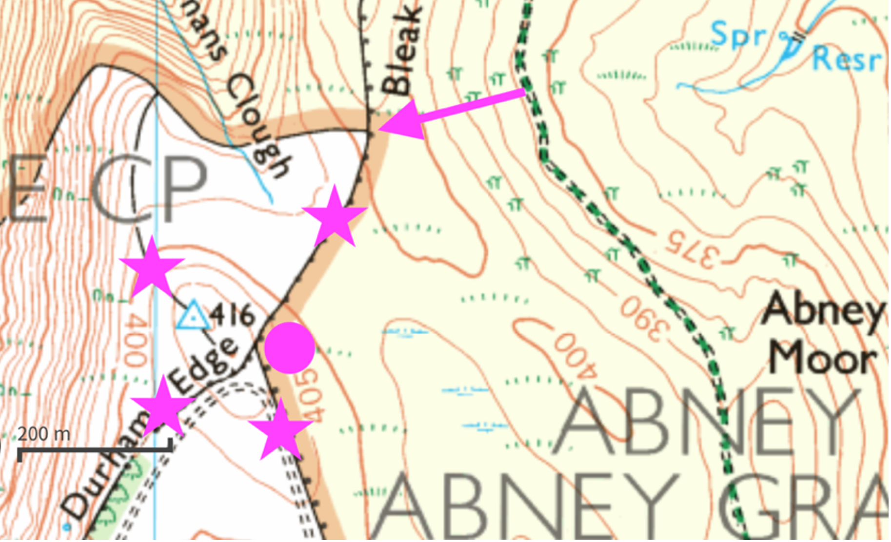
Segment 5 – Brough to Winhill (7.54 km, 318 m): after crossing Abney Moor, take Brough Lane into Brough, cross the main Hope Valley Rd A6187 to Hope Station and cross the railway track using the platform bridge. Follow the path to Twitchill Farm, and climb to Winhill Pike (trig 5). An alternative is to take the road to Aston, then climb the eastern side of the hill. There’s more road this way for a slightly shorter distance.
Segment 6– Bamford (5.99 km, 329 m): descend Parkin Clough to Yorkshire Bridge, cross the main road and climb New Rd to the bend. Either continue on the road or bear left on the footpath and take a direct line across the moor on trods to Dennis Knoll car park. Follow Stanage Causeway to the bend, then strike left over the first stile on a direct line to the edge. After a bit of heather bashing, reach the High Nebb trig (trig 6).
Segment 7 – Stanage (3.38 km, 55 m): follow Stanage Edge eastwards, running its full length and climbing up to reach the Stanage trig (trig 7).
Segment 8 – Burbage (3.49 km, 32 m): drop down to Burbage Bridge, briefly joining the Burbage North edge path, but striking off left on the well-trodden path to the Oxstones trig (trig 8).
Segment 9 – Houndkirk to Blacka (3.07 km, 62 m): take the path to Houndkirk Road, joining at the bridge, and reversing the Tigger Tor FR route to Houndkirk Hill. Drop down the other side to reach Hathersage Rd. Turn right up the road for a short distance to the Devil’s Elbow gate. Drop down Devil’s Elbow to the first path junction. Turn left (the only way not signposted) and follow the path to the stream. Continue down the path alongside the stream, which you cross with the path further down. Climb up into the woods all the way up to the wall, where Blacka trig is hidden in the field on the other side (trig 9).
Segment 10 purist option – Sting in the Tail (4.25 km, 170 m): descend on the path through the woods to join Shorts Lane. The purist looking for the full Totley experience will choose the classic Totley Moor FR finish, climbing Shorts Lane to cross the Stepping Stones and up to the bench, dropping down to Strawberry Lees car park, before taking the Sting in the Tail, Horse Field and lap of the cricket pitch to finish at the pavilion.
Segment 10 direct option – Strawberry Lees Lane (2.14 km, 44 m): those who have run out of gas after 30 miles on their feet may prefer the direct footpath joining Shorts Lane to Strawberry Lees Lane, returning to the pavilion via the Blackamoor Chase FR route. No-one is judging you. You have earned that beer.